Weekend of Nov 30 - Dec 1
Saturday morning perception (7:30 review)
The lapse rate looks good with a mild low inversion below 1500' that should disappear once the day heats up. There is some early wind in the balloon and at the La Cumber Peak, but the winds aloft forecast is only calling for 8 knots at 6K from the NE and L&V below ridge line. The 6K wind is forecasted to clock around more to the NNE this afternoon, but remain mild, about 10ish up at 9K. The satellite loop shows more north than east, but it's history rather than the future. Suspect it will likely be NNE up high and SW below the front range ridge in the afternoon.
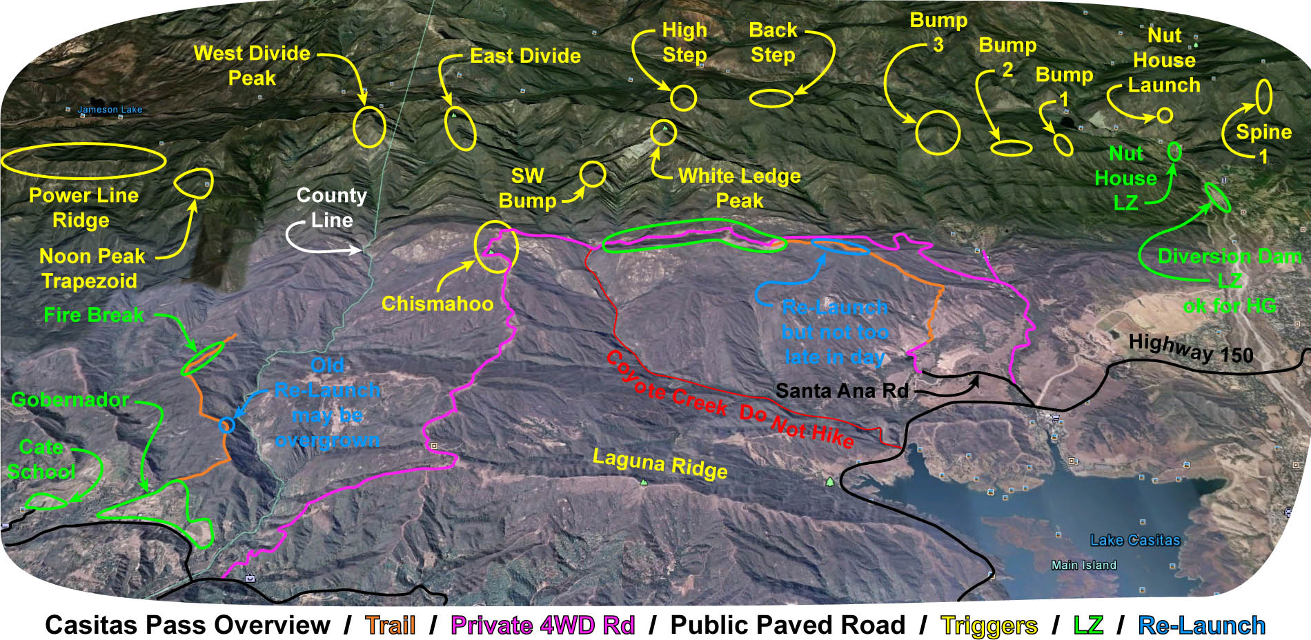
Will likely be a good day to start in Ojai. Preferably from Chiefs, or perhaps the Nuthouse if no one has a permit. No bus schedule yet from either Eagle or FAA. Fillmore toward SB is a maybe, but there is some concern about the early morning inversion below 1500 because you may need to climb out from down low early after crossing the Sespe. If you start in Santa Barbara, I'd recommend trying to get high and stay as high as possible for a westbound leg, then navigating below ridge line on the east bound leg, and if the altitude in the afternoon is good, turning abound at either the High Step or the Back Step just east of White Ledge [http://scpa.info/sites/front_range/casitas_pass/casitas_pass_overview.jpg] for a return leg toward either Summerland or Santa Barbara, once again, staying high to avoid the lower onshore flow from the west.
Sunday looks good also, continued high pressure offshore flow, perhaps less wind at 6K but more downriver drainage and a weaker lapse rate as the center of the high pressure moves overhead.
I can't fly this weekend, but look forward to reading the war stories.
The lapse rate looks good with a mild low inversion below 1500' that should disappear once the day heats up. There is some early wind in the balloon and at the La Cumber Peak, but the winds aloft forecast is only calling for 8 knots at 6K from the NE and L&V below ridge line. The 6K wind is forecasted to clock around more to the NNE this afternoon, but remain mild, about 10ish up at 9K. The satellite loop shows more north than east, but it's history rather than the future. Suspect it will likely be NNE up high and SW below the front range ridge in the afternoon.
Will likely be a good day to start in Ojai. Preferably from Chiefs, or perhaps the Nuthouse if no one has a permit. No bus schedule yet from either Eagle or FAA. Fillmore toward SB is a maybe, but there is some concern about the early morning inversion below 1500 because you may need to climb out from down low early after crossing the Sespe. If you start in Santa Barbara, I'd recommend trying to get high and stay as high as possible for a westbound leg, then navigating below ridge line on the east bound leg, and if the altitude in the afternoon is good, turning abound at either the High Step or the Back Step just east of White Ledge [http://scpa.info/sites/front_range/casitas_pass/casitas_pass_overview.jpg] for a return leg toward either Summerland or Santa Barbara, once again, staying high to avoid the lower onshore flow from the west.
Sunday looks good also, continued high pressure offshore flow, perhaps less wind at 6K but more downriver drainage and a weaker lapse rate as the center of the high pressure moves overhead.
I can't fly this weekend, but look forward to reading the war stories.
